A short time later Pete was corresponding with Brad WA8WDQ who had questions about his antenna pattern. Pete recommended using WSPR to test his antenna's effectiveness.
These two exchanges got me thinking about the radiation pattern of my 135 foot doublet antenna, especially on 20 meters. Where are my lobes, where are my nulls? Following Pete' advice I turned to WSPR. But first, a quick look at the PREDICTED patterns.
ON5AU has on his site a great article by antenna guru L.B. Cebik W4RNL with exactly the info I needed. Above is W4RNL's chart of predicted radiation pattern for 20 meters on a 135 foot doublet. Note the orientation of the wire.
My antenna is oriented almost exactly north-south (broadsides to the east and west). So with a standard north at top map, my pattern on 20 should look like that of W4RNL's chart. What did I get from WSPR? Here is the pattern for an hour or so of 250 milliwatt transmissions from my station using the 135 foot doublet on 20 meters (using homebrew balanced tuner):
You can clearly see at least three of the four predicted lobes (NE, NW, SW).
Now, part of this WSPR pattern could, I suppose, be the result of the geographic distribution of WSPR stations. If there are just more of them in the areas where I am seeing lobes, the pattern could just be the result of geographic distribution. I don't think that is the case, but to test this idea (a bit) I decided to look at the 40 meter pattern.
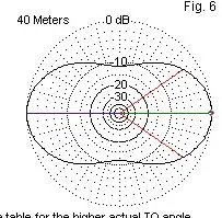
Here is what W4RNL predicted (same north-south antenna orientation):
And here is the WSPR map that I got, again using about 250 milliwatts for about an hour):
I think this pattern matches nicely with the prediction. You don't see the nulls that you see in the 20 meter pattern. You do see some stations directly north of me (as predicted). There does not seem to be a big disparity in the geographic distribution of WSPR stations.
One note on the use of WSPR: I started out using WSPR in receive mode, thinking that the pattern I'd see would be similar on receive or transmit due to the antenna reciprocity principle. But I worried that the results could be easily skewed by higher power WSPR stations. So I shifted to the transmit mode and limited my output to 250 milliwatts.
Here is the W4RNL chart showing the patterns for all the bands:
Here is the azimuth chart for my location:


